Blog Post — The Inca Highway Launch
May 31, 2026
Body
At its height in the early sixteenth century, the Inca Empire administered roughly twelve million people across 2,500 miles of the Andes. It ran from southern Colombia through Ecuador, Peru, and Bolivia into Chile and northwest Argentina. It controlled coastal desert, Amazonian jungle, high altiplano above 15,000 feet, and the entire central spine of mountains in between. It moved armies. It ran a continent-scale census. It stored enough food in state granaries to feed entire provinces through droughts. It resettled hundreds of thousands of people across its territory as a deliberate policy.
It did all of this without writing, without coined money, without iron, without horses, and without a single draft animal capable of pulling a wheeled cart.
That last fact is the one that has historically embarrassed political scientists the most. Every standard checklist of what a complex state requires includes some version of literacy, monetary exchange, and roads suitable for wheels. The Inca Empire had exactly one of those three — the road. And the road did not carry carts. It carried feet and llamas.
If you take the standard checklist seriously, Tawantinsuyu should not have worked. But it did. For roughly a century, before smallpox and civil war broke it on the eve of the Spanish arrival, the Inca state was one of the most administratively capable polities in the pre-modern world.
The road is the explanation.
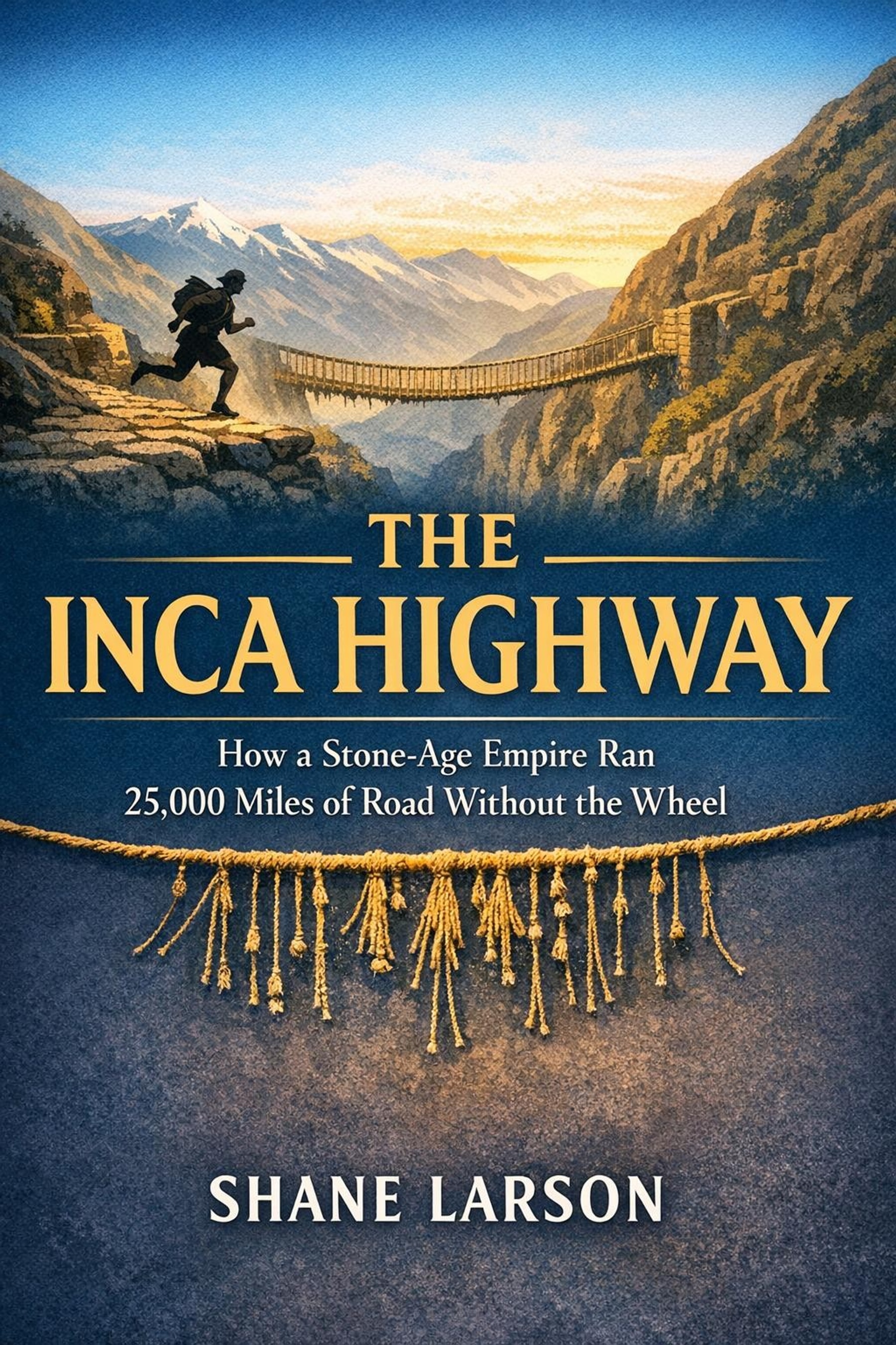
The Qhapaq Ñan
The Qhapaq Ñan — the Great Road, in Quechua — was a network of roughly 25,000 miles of paved or improved highway running the length of the empire. Two trunk routes formed the backbone. One climbed the highlands from Quito in the north, through Cajamarca and Huánuco Pampa, into Cusco and on down to Lake Titicaca, then further south into Bolivia and Chile. The other ran the coast through the Atacama desert, where it had to be carried on engineered causeways across stretches of sand and salt flat. Hundreds of lateral roads connected the two trunks and reached out into the conquered provinces.
The construction varied with the terrain. At altitude, the road was stone-paved, often with curbs to channel runoff. Through marshes, it was raised on engineered embankments. Up impossibly steep slopes, it was stepped — actual stone staircases climbing the side of the mountain. Across the canyons that the Andes specialize in, it crossed on woven-grass suspension bridges, hand-twisted by the thousands and rebuilt on an annual cycle by hereditary specialists.
There is nothing else like it from the pre-modern world at this latitude and altitude. The Roman road system was larger in absolute mileage but ran across far gentler terrain. The Persian royal road was a single trunk line, not a continent-scale network. The Mongol yam was a relay system, not a paved infrastructure. The closest comparison in engineering ambition is the Han Chinese imperial road, and that comparison is closer than most casual surveys admit. The Inca road was a state-level infrastructure project of the same order of magnitude.
It was built by mit'a — a rotating labor tax. Every adult male in the empire owed the state a certain number of weeks of labor per year, drawn by lot, organized by local officials. The mit'a built the road, maintained the road, staffed the way stations along the road, and filled the storehouses that the road connected. The tax was not paid in coin because there was no coin. It was paid in person-weeks.
The Chasquis
Running on top of the road was the chasqui relay — the messenger system that turned the highway into something more than a transportation network. The chasquis were stationed in pairs at posts every couple of miles. When a message came in, the runner who had been resting sprinted out to meet the incoming runner. The handoff was done at a flat-out run. The relieved runner walked back to the post to wait for the next call.
A message could move along this system at roughly 150 miles a day along the highland trunk road. From Quito to Cusco — about 1,200 miles, across some of the most punishing terrain on earth — a chasqui message could arrive in roughly a week. That is faster than the Persian royal road. Faster than the Roman cursus publicus. Comparable to the Pony Express at its peak, except with no horses.
The chasquis carried verbal messages, memorized at the start and repeated down the line. They carried quipus — knotted cords with administrative data. And, in the stories that make the system real, they carried physical goods for the emperor. Fresh fish from the Pacific to Cusco — two hundred miles inland, at 11,000 feet — within twenty-four hours. The chronicles record this and the modern reconstruction supports it. The chasqui system was fast enough to run a fifteenth-century cold chain on foot.
The Quipus
The Inca administration ran on knotted cords. A quipu is a primary cord, sometimes thick and dyed, with pendant cords hanging from it. The pendant cords carry knots at varying positions. Knot position encodes a decimal value. The kind of knot — single, long, figure-eight — encodes the digit. Color encodes the category being counted.
The numerical quipus are now well understood. They were used for census records, tribute accounting, storehouse inventories, military rolls, calendars, and probably astronomical observations. The Khipu Database Project at Harvard has catalogued hundreds of surviving examples and decoded much of the structure.
The harder question is whether there were narrative quipus — knotted cords that encoded something more than numbers. Some quipus do not parse as decimal-numerical and behave as if they are encoding something else. Toponyms. Genealogies. Possibly speech. The decipherment debate is alive and the field is moving. Whatever the final answer turns out to be, the existing decimal quipus alone are enough to demonstrate that the Inca administration ran a record-keeping system competitive with any literate empire of the same era.
The Storehouses
The road and the chasquis and the quipus together built one of the most impressive logistics achievements in the pre-modern world: the imperial storehouse system. At sites like Huánuco Pampa, thousands of small stone granaries — qullqas — stood in long rows, ventilated to keep grain dry, organized for inventory. The Spanish chroniclers who first saw the surviving examples reported that the storehouses still held food years after the empire collapsed.
The strategy was simple in concept. Local mit'a labor produced surplus. The surplus moved into state warehouses. Quipus tracked what was where. When a province had a bad year — drought, frost, blight — the state opened the warehouses and redistributed. When the army moved through, the warehouses fed it. When a population was resettled — and the Inca state did this constantly, as a deliberate policy of breaking up potentially rebellious provinces — the warehouses underwrote the move.
This is a state running on redistribution, not exchange. There is no monetary economy here in the modern sense, and no real need for one. The state collects labor, produces surplus, stores surplus, and moves surplus. The whole thing is held together by the road and by the cord.
Why the System Stopped
In 1527, before any Spaniard had set foot in Peru, smallpox arrived in the empire. It came south from the Caribbean, through Panama, through the Inca road network — which was efficient enough to be an efficient vector for the virus. The emperor Huayna Capac died of it. His designated heir Ninan Cuyochi died of it. The succession was thrown to two of his other sons, Huáscar in Cusco and Atahualpa in Quito, who fought a civil war for five years that gutted the imperial elite and the regular army.
Pizarro arrived in 1532, with 168 men, into the immediate aftermath. The empire he encountered was not the empire that had been functioning a decade earlier. It was a state in succession crisis, with its administrative class decimated and its provincial loyalties fragmenting. What happened at Cajamarca in November of 1532 — the ambush, the captivity of Atahualpa, the ransom, the execution — was extraordinary by any measure, but it was not the conquest of a healthy empire. It was the decapitation of one that was already dying.
This is the current historiography and it has been the current historiography for at least thirty years. The new book follows it closely. Pizarro succeeded because the empire was already broken and because he showed up at exactly the right moment with the right kind of force. Spanish steel and Spanish horses were real advantages, but they were not magic. Disease, timing, and the exploitation of an existing fault line did the bulk of the work.
What the Road Has To Teach
The Qhapaq Ñan is now a UNESCO World Heritage Site — a continuous designation spanning six modern countries, recognized in 2014. Sections of it are still walkable. The most famous is the Inca Trail to Machu Picchu, but it is a tiny fraction of what survives. The road network is the largest single archaeological feature in South America.
What it teaches, more than anything else, is that the canonical state-capacity checklist is provincial. Different geographies select for different tools. The Andes selected for runners, not riders. For knotted cords, not papyrus. For redistribution, not coin. The Inca Empire is not a story of a "primitive" state that almost made it. It is the story of a state that solved every problem its geography handed it, and solved most of them better than empires that had all the supposedly necessary tools.
The road was the empire. Without it, no chasquis. Without it, no storehouses worth the name. Without it, no integration of conquered provinces. The Qhapaq Ñan was not a piece of imperial infrastructure. It was the organizing principle of the imperial system.
That is the book.